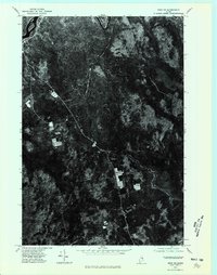
1975 Map of Winn NE
USGS Topo · Published 1980About this map
Mattawamkeag River flows through this corner of Penobscot County, defining the northern edge of the landscape recorded in this 1975 orthophotograph. The settlement of Winn sits as a primary point of reference in a territory dominated by dense woodlands and timber resource management. Captured through aerial photography rather than traditional topographic lines, this sheet reveals the physical footprint of the Maine woods during the mid-1970s, showing the precise layout of forest clearings, access roads, and riverbank vegetation. The imagery provides a clear look at the spatial relationship between the river corridor and the scattered development of the village, offering a specialized visual record for those studying the land-use patterns of Northern Maine before the digital mapping era.
Find a feature on this map
2 named features on this map. Tap any name to fly to it.
Don’t see what you’re looking for? This feature index may not catch every label — zoom into the map to look around manually.
Map Details
Editions of this 1975 Winn NE Map
This is the sole edition of this map. No revisions or reprints were ever made.
Other maps of this area

1920 · Winn
USGS Topo · 1:62,500

1931 · Springfield
USGS Topo · 1:48,000

1934 · Springfield
USGS Topo · 1:62,500

1940 · Mattawamkeag
USGS Topo · 1:62,500

1941 · Wytopitlock
USGS Topo · 1:62,500

1942 · Mattawamkeag
USGS Topo · 1:62,500

1943 · Wytopitlock
USGS Topo · 1:62,500

1954 · Millinocket
USGS Topo · 1:250,000

1958 · Millinocket
USGS Topo · 1:250,000

1960 · Millinocket
USGS Topo · 1:250,000