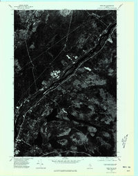
1975 Map of Winn NW
USGS Topo · Published 1980About this map
The settlement of Woodville and its surrounding forest lands define this 1975 orthophoto survey of the Penobscot region. Unlike traditional topographic maps, this imagery provides a direct visual record of land use, revealing the stark geometry of logging tracts and cleared fields against the dense Maine woods. The dark, sprawling waters of Caribou Pond dominate the southern portion of the quadrangle, serving as a primary drainage point for the area's complex network of wetlands and small streams. The orthophoto format allows researchers to trace the exact boundaries of farms and woodlots during the mid-1970s, offering a clear look at the agricultural and timber patterns of the day.
Find a feature on this map
2 named features on this map. Tap any name to fly to it.
Don’t see what you’re looking for? This feature index may not catch every label — zoom into the map to look around manually.
Map Details
Editions of this 1975 Winn NW Map
This is the sole edition of this map. No revisions or reprints were ever made.
Other maps of this area

1920 · Winn
USGS Topo · 1:62,500

1940 · Mattawamkeag
USGS Topo · 1:62,500

1942 · Lincoln
USGS Topo · 1:62,500

1942 · Mattawamkeag
USGS Topo · 1:62,500

1951 · Millinocket
USGS Topo · 1:62,500

1954 · Millinocket
USGS Topo · 1:250,000

1957 · Lincoln
USGS Topo · 1:62,500

1958 · Millinocket
USGS Topo · 1:250,000

1960 · Millinocket
USGS Topo · 1:250,000
1960 · Winn
USGS Topo · 1:62,500