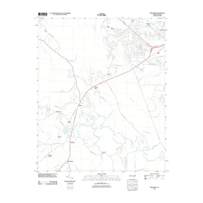
2010 Map of Winnabow
USGS Topo · Published 2010About this map
Winnabow and the surrounding Brunswick County lowlands are defined by a complex network of coastal plains drainage, where Town Creek and Rice Creek meander through a landscape of named swamps and branches. This 2010 survey documents the intersection of rural heritage and modern transportation, showing established settlements like Bishop, Lanvale, and Henrytown alongside newer residential patterns near Leland Post Office. The local geography is tied to its water, with Rice Creek Bridge and Sturgeon Creek Bridge serving as vital connectors. Genealogical interest is anchored by Benton Cemetery and Nelson Cemetery, while the presence of the Winnabow Airport and the distinct community of Easy Hill illustrates the area's transition toward more diverse land use at the start of the decade. The map reveals how the modern road network, including Governors Rd SE and Village Rd NE, has shaped the growth of communities like Spring Hill and Bell Swamp.
Find a feature on this map
58 named features on this map. Tap any name to fly to it.
Don’t see what you’re looking for? This feature index may not catch every label — zoom into the map to look around manually.
Map Details
Editions of this 2010 Winnabow Map
This is the sole edition of this map. No revisions or reprints were ever made.
Other maps of this area

1942 · Wilmington
USGS Topo · 1:62,500

1943 · Funston
USGS Topo · 1:24,000

1943 · Winnabow
USGS Topo · 1:24,000

1943 · Bolivia
USGS Topo · 1:24,000

1943 · Lewis Swamp
USGS Topo · 1:24,000

1944 · Bolivia
USGS Topo · 1:31,680

1944 · Winnabow
USGS Topo · 1:31,680

1944 · Lewis Swamp
USGS Topo · 1:31,680

1947 · Rocky Point
USGS Topo · 1:62,500

1948 · Wilmington
USGS Topo · 1:62,500