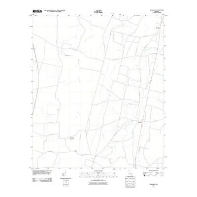
2011 Map of Winokur
USGS Topo · Published 2011About this map
Winokur and Bachlott anchor this portion of Brantley County, appearing here as they were during the early 21st century. The landscape is defined by the slow drainage of the Georgia coastal plain, where Buffalo Creek and its tributary, Little Buffalo Creek, wind through a network of rural county roads. Distinctive landforms such as White Oak Hammock and Briar Island rise slightly above the surrounding wetlands, providing identifiable landmarks in an area dominated by timber and agricultural interests. The road network, including family-named routes like Oberry Rd and John S Pond Rd, reflects a history of local land ownership and passage through the Cross Swamp region. This map illustrates the intersection of modern transportation corridors with the enduring natural hydrology of the southern Georgia woods.
Find a feature on this map
25 named features on this map. Tap any name to fly to it.
Don’t see what you’re looking for? This feature index may not catch every label — zoom into the map to look around manually.
Map Details
Editions of this 2011 Winokur Map
This is the sole edition of this map. No revisions or reprints were ever made.
Other maps of this area

1917 · Nahunta
USGS Topo · 1:62,500

1917 · Boulogne
USGS Topo · 1:62,500

1918 · Folkston
USGS Topo · 1:62,500

1918 · Nahunta
USGS Topo · 1:62,500

1919 · Boulogne
USGS Topo · 1:62,500

1946 · Brunswick
USGS Topo · 1:250,000

1948 · Jacksonville
USGS Topo · 1:250,000

1948 · Brunswick
USGS Topo · 1:250,000

1953 · Waycross
USGS Topo · 1:250,000

1954 · Valdosta
USGS Topo · 1:250,000