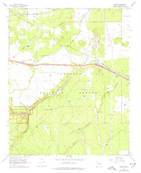
1968 Map of Winona
USGS Topo · Published 1977About this map
Winona and the surrounding high country of the Coconino National Forest are defined by volcanic geology and the critical transport corridors of the Atchison Topeka and Santa Fe railroad. The landscape is marked by numerous tanks used for water storage in this arid environment, such as Ely Tank and Onyx Tank, supporting both local ranching at Foster Ranch and the operational needs of the rail lines. The northern section of Walnut Canyon National Monument occupies the southwest, where the steep terrain of Walnut Canyon drops away from the plateau.
Find a feature on this map
44 named features on this map. Tap any name to fly to it.
Don’t see what you’re looking for? This feature index may not catch every label — zoom into the map to look around manually.
Map Details
Editions of this 1968 Winona Map
3 editions found
Other maps of this area

1886 · San Francisco Mtns
USGS Topo · 1:250,000

1891 · San Francisco Mtns
USGS Topo · 1:250,000

1894 · San Francisco Mtns
USGS Topo · 1:250,000

1899 · San Francisco Mtns
USGS Topo · 1:250,000

1908 · Flagstaff
USGS Topo · 1:125,000

1912 · Flagstaff
USGS Topo · 1:125,000

1947 · Flagstaff
USGS Topo · 1:250,000

1954 · Flagstaff
USGS Topo · 1:250,000

1958 · Flagstaff
USGS Topo · 1:250,000

1960 · Flagstaff
USGS Topo · 1:250,000