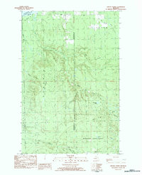
1982 Map of Winona North
USGS Topo · Published 1983About this map
Mishwabic State Forest dominates this landscape along the border of Ontonagon and Houghton counties, where the dense timberlands meet the southern shore of Lake Superior. The 1980s terrain is defined by a complex drainage network, including the Misery River, Little Elm River, and Sleepy River, which cut through the townships of Stanton, Bohemia, and Greenland. Small settlement pockets like Winona and Ahola sit in the southeast, while the interior is marked by forestry and resource extraction sites such as Camp 18 and a Gravel Pit.
Find a feature on this map
25 named features on this map. Tap any name to fly to it.
Don’t see what you’re looking for? This feature index may not catch every label — zoom into the map to look around manually.
Map Details
Editions of this 1982 Winona North Map
This is the sole edition of this map. No revisions or reprints were ever made.
Other maps of this area

1950 · Greenland
USGS Topo · 1:62,500

1951 · Greenland
USGS Topo · 1:62,500

1954 · Graveraet River
USGS Topo · 1:24,000

1954 · Rockhouse Point
USGS Topo · 1:24,000

1954 · Winona
USGS Topo · 1:62,500

1958 · Hancock
USGS Topo · 1:250,000

1958 · Iron River
USGS Topo · 1:250,000

1960 · Iron River
USGS Topo · 1:250,000

1960 · Hancock
USGS Topo · 1:250,000

1961 · Iron River
USGS Topo · 1:250,000