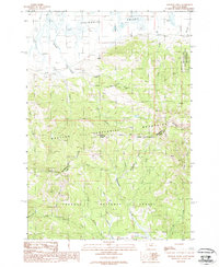
1988 Map of Winslow Creek
USGS Topo · Published 1988About this map
The Continental Divide defines the spine of this 1988 survey, marking the high-altitude boundary between Montana and Idaho and the jurisdictional line for Beaverhead and Clark counties. The northern landscape transitions from the open Centennial Valley, where the 7L Ranch and a small Cem are located, into the densely forested slopes of the Targhee National Forest. High-country resource extraction is evidenced by a Coal Mine and a Prospect located near Coon Creek in the central portion of the sheet.
Find a feature on this map
32 named features on this map. Tap any name to fly to it.
Don’t see what you’re looking for? This feature index may not catch every label — zoom into the map to look around manually.
Map Details
Editions of this 1988 Winslow Creek Map
This is the sole edition of this map. No revisions or reprints were ever made.
Other maps of this area

1950 · Lower Red Rock Lake
USGS Topo · 1:62,500

1955 · Dubois
USGS Topo · 1:250,000

1955 · Ashton
USGS Topo · 1:250,000

1958 · Dubois
USGS Topo · 1:250,000

1958 · Ashton
USGS Topo · 1:250,000

1960 · Ashton
USGS Topo · 1:250,000

1968 · Big Table Mountain
USGS Topo · 1:24,000

1968 · Antelope Peak
USGS Topo · 1:24,000

1972 · Antelope Valley
USGS Topo · 1:24,000

1972 · Kilgore
USGS Topo · 1:24,000