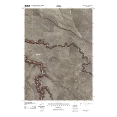
2010 Map of Winter Camp
USGS Topo · Published 2010About this map
The Bruneau River and Clover Creek define the remote canyonlands of Owyhee County on this 2010 topographic study. Centered on the confluence of these water bodies, the landscape is characterized by high plateau features such as Long Butte and Lookout Butte. The settlement of Winter Camp sits at a strategic point near where these drainages meet, served by the winding route of Clover Three Creek Rd. The presence of Juniper Tree Draw and several unnamed trails suggests a region primarily dedicated to ranching and livestock management, preserving a traditional high-desert land use pattern. The map's fine contour detail captures the steep descents into the river breaks, contrasting the flat volcanic benches with the deeply carved aquatic corridors below.
Find a feature on this map
7 named features on this map. Tap any name to fly to it.
Don’t see what you’re looking for? This feature index may not catch every label — zoom into the map to look around manually.
Map Details
Editions of this 2010 Winter Camp Map
This is the sole edition of this map. No revisions or reprints were ever made.
Other maps of this area

1955 · Twin Falls
USGS Topo · 1:250,000

1956 · Blue Butte
USGS Topo · 1:62,500

1956 · Winter Camp
USGS Topo · 1:62,500

1958 · Twin Falls
USGS Topo · 1:250,000

1979 · Stiff Tree Draw
USGS Topo · 1:24,000

1979 · Cave Draw
USGS Topo · 1:24,000
1980 · Austin Butte
USGS Topo · 1:24,000

1980 · Clover Butte North
USGS Topo · 1:24,000
1980 · Black Butte West
USGS Topo · 1:24,000
1980 · Crowbar Gulch
USGS Topo · 1:24,000