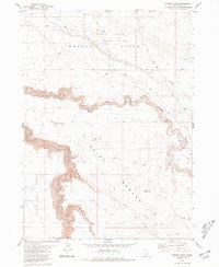
1980 Map of Winter Camp
USGS Topo · Published 1981About this map
Bruneau Desert and its surrounding high-plateau landscapes define this 1980 survey, dominated by the deep incisions of Bruneau Canyon. The northern portion of the quadrangle is largely occupied by the Saylor Creek Air Force Range, a large military training area that contrasts with the grazing-oriented infrastructure of the Inside Desert and Blackstone Desert to the south. Human presence is sparse, centered on the isolated Winter Camp settlement in the east, which is supported by a Corral and Well. Significant topographic landmarks include Lookout Butte and Long Butte, which rise above the surrounding flats. The map traces the winding paths of Clover Creek and East Fork Clover Creek, alongside several drainages such as Sheepshead Draw and Juniper Tree Draw, revealing a desert water system essential for the region's remote ranching operations.
Find a feature on this map
21 named features on this map. Tap any name to fly to it.
Don’t see what you’re looking for? This feature index may not catch every label — zoom into the map to look around manually.
Map Details
Editions of this 1980 Winter Camp Map
This is the sole edition of this map. No revisions or reprints were ever made.
Other maps of this area

1955 · Twin Falls
USGS Topo · 1:250,000

1956 · Blue Butte
USGS Topo · 1:62,500

1956 · Winter Camp
USGS Topo · 1:62,500

1958 · Twin Falls
USGS Topo · 1:250,000

1979 · Stiff Tree Draw
USGS Topo · 1:24,000

1979 · Cave Draw
USGS Topo · 1:24,000
1980 · Austin Butte
USGS Topo · 1:24,000

1980 · Clover Butte North
USGS Topo · 1:24,000
1980 · Black Butte West
USGS Topo · 1:24,000
1980 · Crowbar Gulch
USGS Topo · 1:24,000