
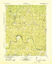
1943 Map of Winterpock
USGS Topo · Published 1961About this map
The small settlement of Winterpock serves as a focal point in this 1943 survey, situated amidst the complex drainage patterns of south-central Virginia. The landscape is characterized by a dense network of tributaries including Winterpock Creek, Manchester Branch, and Second Branch, all contributing to the Appomattox River which winds along the southern edge of the sheet. This river corridor serves as a significant boundary, marking the tri-county junction of Chesterfield, Amelia, and Dinwiddie counties. The distribution of Bethia, Centenary, Tabernacle, and Second Branch Ch alongside the Winterpock School suggests a community organized around localized rural centers during the mid-war era. Of particular note is the industrial presence indicated by a significant Pipeline cutting across the landscape, contrasting with the natural terrain of Goose Island and the numerous small runs and creeks.
Find a feature on this map
20 named features on this map. Tap any name to fly to it.
Don’t see what you’re looking for? This feature index may not catch every label — zoom into the map to look around manually.
Map Details
Editions of this 1943 Winterpock Map
This is the sole edition of this map. No revisions or reprints were ever made.
Other maps of this area

1897 · Amelia
USGS Topo · 1:125,000

1943 · Chesterfield
USGS Topo · 1:31,680

1943 · Goodes Bridge
USGS Topo · 1:31,680

1943 · Hallsboro
USGS Topo · 1:31,680

1943 · Beach
USGS Topo · 1:24,000

1943 · Clayville
USGS Topo · 1:24,000

1943 · Church Road
USGS Topo · 1:24,000

1943 · Sutherland
USGS Topo · 1:24,000

1943 · Richmond
USGS Topo · 1:250,000
1944 · Winterpock
USGS Topo · 1:31,680