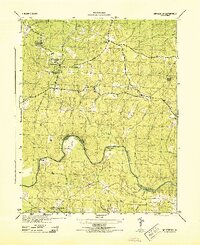
1944 Map of Winterpock
USGS Topo · Published 1944About this map
Winterpock and Whites Store anchor this mid-century topographic study, which reveals the rural landscape of southern Chesterfield County before major suburban expansion. The area is defined by a dense network of watercourses, including Winterpock Creek, Rocky Run, and Second Branch, all draining toward the winding Appomattox River. At the river's bend, Goose Island sits near the junction of the Amelia and Dinwiddie county lines.
Find a feature on this map
23 named features on this map. Tap any name to fly to it.
Don’t see what you’re looking for? This feature index may not catch every label — zoom into the map to look around manually.
Map Details
Editions of this 1944 Winterpock Map
This is the sole edition of this map. No revisions or reprints were ever made.
Other maps of this area

1897 · Amelia
USGS Topo · 1:125,000

1943 · Chesterfield
USGS Topo · 1:31,680

1943 · Goodes Bridge
USGS Topo · 1:31,680

1943 · Hallsboro
USGS Topo · 1:31,680

1943 · Beach
USGS Topo · 1:24,000

1943 · Clayville
USGS Topo · 1:24,000

1943 · Church Road
USGS Topo · 1:24,000

1943 · Winterpock
USGS Topo · 1:24,000

1943 · Sutherland
USGS Topo · 1:24,000

1943 · Richmond
USGS Topo · 1:250,000