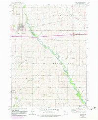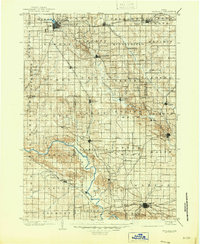
1903 Map of Winthrop
USGS Topo · Published 1946About this map
The Wapsipinicon River and Cedar River carve distinct drainage patterns across this turn-of-the-century landscape, framing a region defined by its intensive early rail development. At the northern end of the survey, Independence serves as a major hub where the Illinois Central R. R. and Burlington Cedar Rapids and Northern R. R. intersect, driving the growth of surrounding settlements like Winthrop and Masonville. To the south, the county seat of Marion anchors the map, showing the dense network of the Chicago Milwaukee and St Paul R. R. as it connects the agrarian prairies to emerging industrial centers. The terrain transitions from the broad river valleys to the high, open grounds of Prairie and Middlefield townships, where smaller hamlets such as Quasqueton and Troy Mills established themselves along the water's edge long before modern highway systems reorganized the Iowa interior.
Find a feature on this map
85 named features on this map. Tap any name to fly to it.
Don’t see what you’re looking for? This feature index may not catch every label — zoom into the map to look around manually.
Map Details
Editions of this 1903 Winthrop Map
2 editions found

Historical Maps of Cedar Rapids Through Time
7 maps found