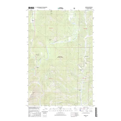
2017 Map of Winton
USGS Topo · Published 2017About this map
The Wenatchee River carves a deep path through Chelan County, defining the western and central geography of this 2017 survey. The landscape is dominated by the steep slopes of Natapoc Ridge and Natapoc Mtn to the north, giving way to the dramatic Tumwater Canyon as the water flows south toward Lake Jolanda. Small settlements like Chiwaukum and Winton are situated along the valley floor, while the eastern portion of the map is shaped by the Chumstick Cr drainage and the small community of Chumstick.
Find a feature on this map
39 named features on this map. Tap any name to fly to it.
Don’t see what you’re looking for? This feature index may not catch every label — zoom into the map to look around manually.
Map Details
Editions of this 2017 Winton Map
This is the sole edition of this map. No revisions or reprints were ever made.
Other maps of this area

1901 · Chiwaukum
USGS Topo · 1:125,000

1904 · Chiwaukum
USGS Topo · 1:125,000

1957 · Wenatchee
USGS Topo · 1:250,000

1964 · Leavenworth
USGS Topo · 1:62,500

1965 · Chiwaukum Mts
USGS Topo · 1:62,500

1965 · Wenatchee Lake
USGS Topo · 1:62,500
1968 · Sugarloaf Peak
USGS Topo · 1:24,000
1968 · Plain
USGS Topo · 1:24,000
1975 · Chelan
USGS Topo · 1:100,000
1989 · Big Jim Mountain
USGS Topo · 1:24,000