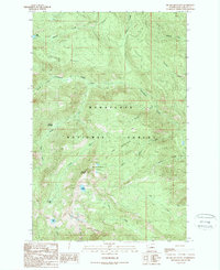
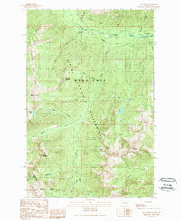
1989 Map of Big Jim Mountain
USGS Topo · Published 1989About this map
Big Jim Mountain dominates this portion of the Wenatchee National Forest, which was documented through a series of aerial photographs and field checks concluding in the late 1980s. The landscape is defined by its high-altitude hydrologic network, including alpine water bodies such as Lake Augusta, Lake Julius, Carter Lake, and Lake Ida. These lakes feed into a complex system of drainage including Chiwaukum Creek and Icicle Creek. Significant topographic landmarks like Mc Cue Ridge and Icicle Ridge frame the drainage basins. Notable interior features include Timothy Meadow and the uniquely named The Badlands near Battle Canyon. This provisional survey provides a precise look at the glacial and fluvial geomorphology before modern environmental shifts, capturing the precise locations of small tributaries like Foolhen Creek and Hatchery Creek.
Find a feature on this map
26 named features on this map. Tap any name to fly to it.
Don’t see what you’re looking for? This feature index may not catch every label — zoom into the map to look around manually.
Map Details
Editions of this 1989 Big Jim Mountain Map
This is the sole edition of this map. No revisions or reprints were ever made.
Other maps of this area

1901 · Chiwaukum
USGS Topo · 1:125,000

1904 · Chiwaukum
USGS Topo · 1:125,000

1957 · Wenatchee
USGS Topo · 1:250,000

1964 · Leavenworth
USGS Topo · 1:62,500

1965 · Chiwaukum Mts
USGS Topo · 1:62,500

1965 · Wenatchee Lake
USGS Topo · 1:62,500
1968 · Plain
USGS Topo · 1:24,000
1975 · Chelan
USGS Topo · 1:100,000
1989 · Leavenworth
USGS Topo · 1:24,000
1989 · Jack Ridge
USGS Topo · 1:24,000