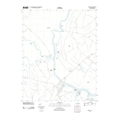
2010 Map of Winton
USGS Topo · Published 2010About this map
The Chowan River snakes through this portion of Hertford County, defining the landscape and historical transport routes of the region. As the river moves past Winton, it meets the Meherrin River and Potecasi Creek, creating a complex network of waterways that once supported numerous river crossings and landings. Traditional river-access points like Parkers Ferry, Jones Ferry, and Mitchell Landing are documented alongside islands such as Dowry Island and Flax Island.
Find a feature on this map
54 named features on this map. Tap any name to fly to it.
Don’t see what you’re looking for? This feature index may not catch every label — zoom into the map to look around manually.
Map Details
Editions of this 2010 Winton Map
This is the sole edition of this map. No revisions or reprints were ever made.
Other maps of this area

1908 · Winton
USGS Topo · 1:62,500

1919 · Boykins
USGS Topo · 1:48,000

1920 · Holland
USGS Topo · 1:62,500

1920 · Boykins
USGS Topo · 1:62,500

1943 · Holland
USGS Topo · 1:62,500

1953 · Norfolk
USGS Topo · 1:250,000

1957 · Holland
USGS Topo · 1:62,500

1966 · Sunbeam
USGS Topo · 1:24,000
1967 · Gates
USGS Topo · 1:24,000
1967 · Riverdale
USGS Topo · 1:24,000