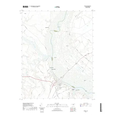
2019 Map of Winton
USGS Topo · Published 2019About this map
The Chowan River and its confluence with the Meherrin River define the wetlands and lowlands of the North Carolina coastal plain. In this 2019 survey, the town of Winton serves as a central hub, situated along the southern banks near where the Meherrin River and Potecasi Creek feed into the larger Chowan waterway. This landscape is a complex network of riverine islands like Dowry Island and Flax Island, alongside extensive marshy areas such as the Whiteoak Pocosin and Runoff Swamp.
Find a feature on this map
71 named features on this map. Tap any name to fly to it.
Don’t see what you’re looking for? This feature index may not catch every label — zoom into the map to look around manually.
Map Details
Editions of this 2019 Winton Map
This is the sole edition of this map. No revisions or reprints were ever made.
Other maps of this area

1908 · Winton
USGS Topo · 1:62,500

1919 · Boykins
USGS Topo · 1:48,000

1920 · Holland
USGS Topo · 1:62,500

1920 · Boykins
USGS Topo · 1:62,500

1943 · Holland
USGS Topo · 1:62,500

1953 · Norfolk
USGS Topo · 1:250,000

1957 · Holland
USGS Topo · 1:62,500

1966 · Sunbeam
USGS Topo · 1:24,000
1967 · Gates
USGS Topo · 1:24,000
1967 · Riverdale
USGS Topo · 1:24,000