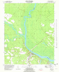
1982 Map of Winton
USGS Topo · Published 1982About this map
The Chowan River and its confluence with the Meherrin River dominate this landscape on the border of Hertford and Gates Counties. The town of Winton serves as a focal point near the river's southern bend, featuring the Brown Sch and an established riverfront character. To the west, the winding path of Potecasi Creek cuts through low-lying terrain, while Sand Banks rise to the east of the main channel.
Find a feature on this map
35 named features on this map. Tap any name to fly to it.
Don’t see what you’re looking for? This feature index may not catch every label — zoom into the map to look around manually.
Map Details
Editions of this 1982 Winton Map
This is the sole edition of this map. No revisions or reprints were ever made.
Other maps of this area

1908 · Winton
USGS Topo · 1:62,500

1919 · Boykins
USGS Topo · 1:48,000

1920 · Holland
USGS Topo · 1:62,500

1920 · Boykins
USGS Topo · 1:62,500

1943 · Holland
USGS Topo · 1:62,500

1953 · Norfolk
USGS Topo · 1:250,000

1957 · Holland
USGS Topo · 1:62,500

1966 · Sunbeam
USGS Topo · 1:24,000
1967 · Gates
USGS Topo · 1:24,000
1967 · Riverdale
USGS Topo · 1:24,000