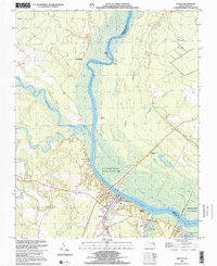
2000 Map of Winton
USGS Topo · Published 2002About this map
The Chowan River dominates the center of this landscape, its wide channel and associated wetlands shaping the boundary between Hertford and Gates counties. This riverine environment is defined by the Chowan Swamp State Game Land, which covers the eastern bank with a network of creeks and marshes including Buckhorn Creek and Catherine Creek. On the western shore, the town of Winton serves as a local hub, featuring institutional landmarks like the Brown Sch and Mt Moriah Ch.
Find a feature on this map
35 named features on this map. Tap any name to fly to it.
Don’t see what you’re looking for? This feature index may not catch every label — zoom into the map to look around manually.
Map Details
Editions of this 2000 Winton Map
This is the sole edition of this map. No revisions or reprints were ever made.
Other maps of this area

1908 · Winton
USGS Topo · 1:62,500

1919 · Boykins
USGS Topo · 1:48,000

1920 · Holland
USGS Topo · 1:62,500

1920 · Boykins
USGS Topo · 1:62,500

1943 · Holland
USGS Topo · 1:62,500

1953 · Norfolk
USGS Topo · 1:250,000

1957 · Holland
USGS Topo · 1:62,500

1966 · Sunbeam
USGS Topo · 1:24,000
1967 · Gates
USGS Topo · 1:24,000
1967 · Riverdale
USGS Topo · 1:24,000