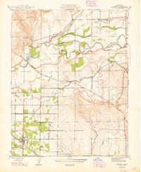
1948 Map of Winton
USGS Topo · Published 1948About this map
The Merced River winds through this Central Valley landscape, carving a wide floodplain marked by the Ingalsbe Slough and Dana Slough. This 1948 revision of earlier 1914 surveys documents a transition from cattle ranching to more intensive irrigation agriculture, evidenced by the sprawling network of waterworks like the Escaladian Canal and Ward Canal. The settlement of Winton serves as a hub for the region, positioned along the Atchison Topeka and Santa Fe railroad, where industrial sites like Castle Field and the U S Military Reservation indicate the area's strategic significance during the mid-century era. Family-named properties such as Giesbrecht Ranch, Langdon Ranch, and Rancho de Cabodon are interspersed among rural schools like Arundel Sch and Washington Sch, providing a detailed look at the social and economic geography of Merced County at this time.
Find a feature on this map
42 named features on this map. Tap any name to fly to it.
Don’t see what you’re looking for? This feature index may not catch every label — zoom into the map to look around manually.
Map Details
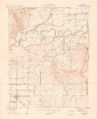
Editions of this 1948 Winton Map
2 editions found
Other maps of this area

1893 · Sonora
USGS Topo · 1:125,000

1896 · Sonora
USGS Topo · 1:125,000

1897 · Sonora
USGS Topo · 1:125,000

1898 · Sonora
USGS Topo · 1:125,000

1913 · Dickenson
USGS Topo · 1:31,680

1914 · Merced
USGS Topo · 1:31,680

1916 · Three Tree Flat
USGS Topo · 1:31,680

1916 · Hopeton
USGS Topo · 1:31,680

1916 · Cressey
USGS Topo · 1:31,680

1916 · Montpellier
USGS Topo · 1:31,680