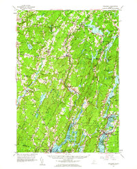
1957 Map of Wiscasset
USGS Topo · Published 1964About this map
The Sheepscot River and Eastern River networks define this coastal Maine landscape during the late 1950s, a period before significant modern development altered the rural character of Lincoln County. This survey highlights the traditional New England settlement pattern, where small villages like Dresden Mills, Head Tide, and Damariscotta Mills grew around water-power sites and tidal estuaries. For the genealogist, the map is remarkably detailed, identifying numerous family burial grounds such as Goodspeed Cem, Marston Cem, and Harriman Cem, alongside rural social centers like St Denis Ch and the Longfellow Sch. The transition from the agricultural interior, marked by heights such as Beech Hill and Telegraph Hill, to the complex tidal reaches of the Damariscotta River and Wiscasset harbor, illustrates the historical reliance on both land and sea for the local economy. Distinctive features like the Health and Welfare Camp near Clary Lake and the various Gravel Pits suggest the area's mid-century recreational and industrial uses.
Find a feature on this map
118 named features on this map. Tap any name to fly to it.
Don’t see what you’re looking for? This feature index may not catch every label — zoom into the map to look around manually.
Map Details
Editions of this 1957 Wiscasset Map
4 editions found
Other maps of this area

1892 · Gardiner
USGS Topo · 1:62,500

1892 · Augusta
USGS Topo · 1:62,500

1893 · Vassalboro
USGS Topo · 1:62,500

1893 · Wiscasset
USGS Topo · 1:62,500

1893 · Boothbay
USGS Topo · 1:62,500

1894 · Bath
USGS Topo · 1:62,500

1898 · Vassalboro
USGS Topo · 1:62,500

1904 · Monhegan
USGS Topo · 1:62,500

1906 · Monhegan
USGS Topo · 1:62,500

1913 · Waldoboro
USGS Topo · 1:48,000