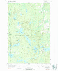
1955 Map of Witch Lake
USGS Topo · Published 1990About this map
The Michigamme State Forest and Iron Range State Forest dominate this Upper Peninsula landscape, where a dense network of glacial lakes and wetlands defined early 20th-century isolation. Two major rail lines, the Chicago and North Western and the Milwaukee St Paul and Pacific, parallel each other along the eastern edge, serving the small settlement of Witbeck. This corridor was essential for moving timber and ore out of the Republic township region, contrasting with the nearly roadless interior to the west. Small seasonal communities and sportsman landmarks like Witch Lake and Fence Lake punctuate the woods, while numerous water bodies like Sundog Lake and Chief Lake suggest the difficult, marshy terrain that governed local land use. This survey captures a moment of quiet industrial transition in the woods of Marquette and Iron counties.
Find a feature on this map
42 named features on this map. Tap any name to fly to it.
Don’t see what you’re looking for? This feature index may not catch every label — zoom into the map to look around manually.
Map Details
Editions of this 1955 Witch Lake Map
3 editions found
Other maps of this area

1899 · Sagola
USGS Topo · 1:62,500

1899 · Witbeck
USGS Topo · 1:62,500

1947 · Kiernan
USGS Topo · 1:24,000

1955 · Witch Lake
USGS Topo · 1:24,000

1955 · Ralph NW
USGS Topo · 1:24,000

1955 · Witch Lake NE
USGS Topo · 1:24,000

1955 · Republic
USGS Topo · 1:62,500

1955 · Republic
USGS Topo · 1:24,000

1955 · Witch Lake
USGS Topo · 1:62,500

1955 · Republic SW
USGS Topo · 1:24,000