
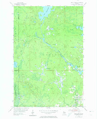
1955 Map of Witch Lake NE
USGS Topo · Published 1956About this map
Michigamme Lake and its winding northern outlet anchor this mid-1950s survey of the Upper Peninsula wilderness. This area, spanning the intersection of Baraga, Marquette, and Iron Counties, is characterized by a dense network of glacial lakes and wetlands, including Dashwa Lake, Luncob Lake, and the sprawling waters of Northwest Lake. The map details the transition from the Iron Range State Forest in the south toward the water-rich Republic territory to the east.
Find a feature on this map
20 named features on this map. Tap any name to fly to it.
Don’t see what you’re looking for? This feature index may not catch every label — zoom into the map to look around manually.
Map Details
Editions of this 1955 Witch Lake NE Map
2 editions found
Other maps of this area

1899 · Witbeck
USGS Topo · 1:62,500

1955 · Champion
USGS Topo · 1:24,000

1955 · Witch Lake
USGS Topo · 1:24,000

1955 · Republic
USGS Topo · 1:62,500

1955 · Republic
USGS Topo · 1:24,000

1955 · Witch Lake
USGS Topo · 1:62,500

1955 · Republic SW
USGS Topo · 1:24,000

1955 · Champion
USGS Topo · 1:62,500

1956 · Three Lakes
USGS Topo · 1:24,000

1956 · Michigamme
USGS Topo · 1:62,500
Featured Places
- Republic Township, MI
- Crystal Falls Township, MI
- Spurr Township, MI
- Marquette County, MI
- Iron County, MI