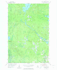
1955 Map of Witch Lake NE
USGS Topo · Published 1974About this map
The Michigamme River flows through a wilderness landscape of interconnected waterways and marshland in the mid-1950s, marking the border between Marquette and Baraga counties. This survey illustrates a period before significant modern development reached this portion of the Iron Range State Forest, where the terrain is dominated by complex drainage systems like Trout Falls Creek and the Spruce River. Large bodies of water such as Lake Michigamme and smaller secluded basins like Dashwa Lake and Nirish Lake characterize the glacial topography.
Find a feature on this map
20 named features on this map. Tap any name to fly to it.
Don’t see what you’re looking for? This feature index may not catch every label — zoom into the map to look around manually.
Map Details
Editions of this 1955 Witch Lake NE Map
2 editions found
Other maps of this area

1899 · Witbeck
USGS Topo · 1:62,500

1955 · Champion
USGS Topo · 1:24,000

1955 · Witch Lake
USGS Topo · 1:24,000

1955 · Witch Lake NE
USGS Topo · 1:24,000

1955 · Republic
USGS Topo · 1:62,500

1955 · Republic
USGS Topo · 1:24,000

1955 · Witch Lake
USGS Topo · 1:62,500

1955 · Republic SW
USGS Topo · 1:24,000

1955 · Champion
USGS Topo · 1:62,500

1956 · Three Lakes
USGS Topo · 1:24,000
Featured Places
- Republic Township, MI
- Crystal Falls Township, MI
- Spurr Township, MI
- Marquette County, MI
- Iron County, MI