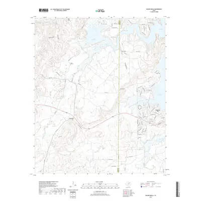
2019 Map of Wizard Wells
USGS Topo · Published 2019About this map
Lake Bridgeport dominates the northern and eastern portions of this North Texas landscape, where the waters of the W Fork Trinity River are impounded along the Jack and Wise County line. The terrain is defined by a network of drainage systems including Beans Cr, Pecan Br, and Jasper Cr, which cut through ridges marked by distinctive elevations like Jim Ned Hill and Bear Knob. In the east, the residential development of Runaway Bay contrasts with the more rural character of Vineyard to the west.
Find a feature on this map
78 named features on this map. Tap any name to fly to it.
Don’t see what you’re looking for? This feature index may not catch every label — zoom into the map to look around manually.
Map Details
Editions of this 2019 Wizard Wells Map
This is the sole edition of this map. No revisions or reprints were ever made.
Other maps of this area

1954 · Sherman
USGS Topo · 1:250,000

1954 · Wichita Falls
USGS Topo · 1:250,000

1958 · Wichita Falls
USGS Topo · 1:250,000

1958 · Sherman
USGS Topo · 1:250,000

1960 · Bridgeport West
USGS Topo · 1:24,000

1960 · Gibtown
USGS Topo · 1:24,000

1960 · Wizard Wells
USGS Topo · 1:24,000
1960 · Boonsville
USGS Topo · 1:24,000
1961 · Perrin
USGS Topo · 1:24,000

1961 · Jacksboro NE
USGS Topo · 1:24,000