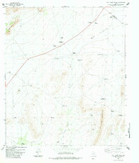
1983 Map of Wolf Camp Hills
USGS Topo · Published 1984About this map
Kincaid Ranch sits at the heart of this West Texas landscape, where the high desert terrain of the Wolf Camp Hills meets the expansive W B Flats. The map reveals a sophisticated network of water management essential for ranching in this environment, dominated by a series of named windmills and tanks that define the local geography. From the Black Muley Booster Windmills in the east to Stewart Windmill in the southwest, these features trace the reliance on groundwater across the Pecos and Brewster county line.
Find a feature on this map
35 named features on this map. Tap any name to fly to it.
Don’t see what you’re looking for? This feature index may not catch every label — zoom into the map to look around manually.
Map Details
Editions of this 1983 Wolf Camp Hills Map
This is the sole edition of this map. No revisions or reprints were ever made.
Other maps of this area

1920 · Longfellow
USGS Topo · 1:125,000

1920 · Marathon
USGS Topo · 1:62,500

1921 · Marathon
USGS Topo · 1:62,500

1923 · Hess Canyon
USGS Topo · 1:62,500

1954 · Fort Stockton
USGS Topo · 1:250,000

1958 · Fort Stockton
USGS Topo · 1:250,000

1968 · Housetop Mountains
USGS Topo · 1:24,000

1968 · Marathon Gap
USGS Topo · 1:24,000

1968 · Dimple Hills
USGS Topo · 1:24,000

1973 · Fort Stockton
USGS Topo · 1:250,000