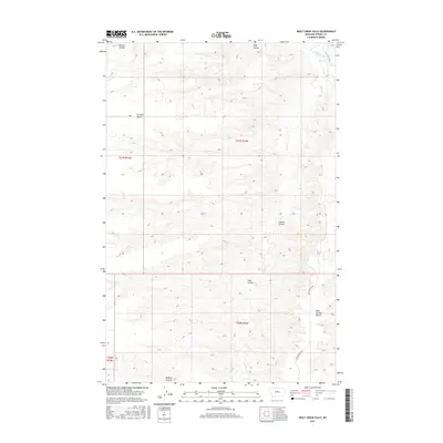
2017 Map of Wolf Creek Falls
USGS Topo · Published 2017About this map
Wolf Creek Falls marks a significant hydrologic feature in this Fergus County landscape, where the waters of Wolf Cr navigate the complex topography of the Montana plains. The map reveals a land defined by high, flat plateaus such as Everson Bench and Bear Springs Bench, which rise above a network of deep drainage channels. These erosional features, locally known as coulees, include Mutton Coulee, King Coulee, and Buffalo Coulee, illustrating the intricate natural irrigation and runoff patterns that feed into the Judith River.
Find a feature on this map
16 named features on this map. Tap any name to fly to it.
Don’t see what you’re looking for? This feature index may not catch every label — zoom into the map to look around manually.
Map Details
Editions of this 2017 Wolf Creek Falls Map
This is the sole edition of this map. No revisions or reprints were ever made.
Other maps of this area

1953 · Starve Out Flat
USGS Topo · 1:24,000

1954 · P N Ranch
USGS Topo · 1:24,000

1954 · Council Island
USGS Topo · 1:24,000

1954 · Lewistown
USGS Topo · 1:250,000

1959 · Lewistown
USGS Topo · 1:250,000

1964 · Wolf Creek Falls
USGS Topo · 1:24,000

1964 · Anderson Bridge
USGS Topo · 1:24,000

1964 · Spring Coulee
USGS Topo · 1:24,000
1978 · Soda Spring Coulee
USGS Topo · 1:24,000

1978 · Wild Bill Flat West
USGS Topo · 1:24,000