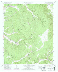
1949 Map of Wolf Pit Ridge
USGS Topo · Published 1973About this map
Wolf Pit Ridge dominates this area of eastern Hardin County, where a complex network of hollows and creek branches defines the rural landscape. In the post-war years, small communities like Center Star and Gillises Mills served as local hubs, connected by winding routes such as Pinhook Road. The map reveals a high density of family-named landmarks and cemeteries, reflecting generations of settlement in the valley of Horse Creek and its tributaries. Educational and spiritual life is anchored by locations like Hardin Hills Academy, Gillis Sch, and Abrams Chapel.
Find a feature on this map
65 named features on this map. Tap any name to fly to it.
Don’t see what you’re looking for? This feature index may not catch every label — zoom into the map to look around manually.
Map Details
Editions of this 1949 Wolf Pit Ridge Map
2 editions found
Other maps of this area

1905 · Waynesboro
USGS Topo · 1:125,000

1936 · Savannah
USGS Topo · 1:24,000

1936 · Wolf Pit Ridge
USGS Topo · 1:24,000

1936 · Hookers Bend
USGS Topo · 1:24,000

1936 · Eagle Creek
USGS Topo · 1:24,000

1936 · Olivehill
USGS Topo · 1:24,000

1936 · Pickwick
USGS Topo · 1:24,000

1936 · Ransom Stand
USGS Topo · 1:24,000

1936 · Lowryville
USGS Topo · 1:24,000

1936 · Martins Mills
USGS Topo · 1:24,000