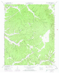
1949 Map of Wolf Pit Ridge
USGS Topo · Published 1974About this map
Gillises Mills and the small settlement of Center Star anchor this survey of the Tennessee hills, recorded just after the war and updated in the early 1970s. The landscape is defined by an intricate network of narrow valleys and named hollows, including Godwin Mill Hollow and Mozier Mill Hollow, suggesting a history of local timber or grain processing along the creeks. Small family communities are evident through numerous hilltop burial grounds such as Wilkerson Cem and Pickens Cem. Education and faith are central to the social fabric of the era, marked by Abrams Chapel, the Gillis Sch, and the Harbert Hills Academy. The rugged geography forced travel along specific routes like Pinhook Road, while terrain features like Wolf Pit Ridge and Baugus Spring provide distinct landmarks for local history researchers and genealogists.
Find a feature on this map
79 named features on this map. Tap any name to fly to it.
Don’t see what you’re looking for? This feature index may not catch every label — zoom into the map to look around manually.
Map Details
Editions of this 1949 Wolf Pit Ridge Map
2 editions found
Other maps of this area

1905 · Waynesboro
USGS Topo · 1:125,000

1936 · Savannah
USGS Topo · 1:24,000

1936 · Wolf Pit Ridge
USGS Topo · 1:24,000

1936 · Hookers Bend
USGS Topo · 1:24,000

1936 · Eagle Creek
USGS Topo · 1:24,000

1936 · Olivehill
USGS Topo · 1:24,000

1936 · Pickwick
USGS Topo · 1:24,000

1936 · Ransom Stand
USGS Topo · 1:24,000

1936 · Lowryville
USGS Topo · 1:24,000

1936 · Martins Mills
USGS Topo · 1:24,000