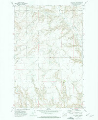
1972 Map of Wolf Point NE
USGS Topo · Published 1975About this map
The northern expanse of the Fort Peck Indian Reservation is defined by a rhythmic drainage pattern of coulees and seasonal creeks in this 1970s topographical record. The landscape is carved by the West Fork Tule Creek and the meandering Little Wolf Creek, which create deep draws across the prairie. This area shows a sparse human footprint, primarily centered on resource extraction and water management, with numerous locations marked as Well and occasional Gravel Pit sites scattered near the plateaus. The presence of Brown Coulee illustrates the erosive character of the terrain, where water remains the primary architect of the geography. This survey provides a clear view of the ranching and resource-based land use within Roosevelt County before modern shifts in industrial or agricultural development changed the local footprint.
Find a feature on this map
7 named features on this map. Tap any name to fly to it.
Don’t see what you’re looking for? This feature index may not catch every label — zoom into the map to look around manually.
Map Details
Editions of this 1972 Wolf Point NE Map
This is the sole edition of this map. No revisions or reprints were ever made.
Other maps of this area

1910 · Cuskers
USGS Topo · 1:62,500

1912 · Chelsea
USGS Topo · 1:62,500

1915 · Tule Valley
USGS Topo · 1:62,500

1915 · Cuskers
USGS Topo · 1:62,500

1916 · Wolf Point
USGS Topo · 1:62,500

1954 · Wolf Point
USGS Topo · 1:250,000

1958 · Wolf Point
USGS Topo · 1:250,000

1972 · Chelsea SW
USGS Topo · 1:24,000

1972 · Wolf Point
USGS Topo · 1:24,000

1972 · Macon
USGS Topo · 1:24,000