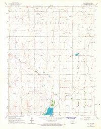
1966 Map of Wolf SW
USGS Topo · Published 1967About this map
Lake Mc Kinney anchors the southern portion of this Kansas landscape, serving as a significant water feature in a region defined by extensive resource extraction. The map documents an intensive network of energy production, with numerous Gas Wells and a Drill Hole scattered across the townships. This industrial layer is superimposed over a topography of drainage features such as James Draw and Mattox Draw. The presence of the Amazon Ditch signifies the irrigation efforts essential to western Kansas land use. Spanning the boundary between Lakin and Deerfield townships, the survey also captures the territorial divisions of the East Bar Bard area, providing a detailed record of the mid-1960s agricultural and mineral infrastructure.
Find a feature on this map
9 named features on this map. Tap any name to fly to it.
Don’t see what you’re looking for? This feature index may not catch every label — zoom into the map to look around manually.
Map Details
Editions of this 1966 Wolf SW Map
This is the sole edition of this map. No revisions or reprints were ever made.
Other maps of this area

1891 · Larned
USGS Topo · 1:125,000

1900 · Lakin
USGS Topo · 1:125,000

1955 · Dodge City
USGS Topo · 1:250,000

1955 · Scott City
USGS Topo · 1:250,000

1958 · Dodge City
USGS Topo · 1:250,000

1958 · Scott City
USGS Topo · 1:250,000

1959 · Dodge City
USGS Topo · 1:250,000

1960 · Deerfield
USGS Topo · 1:24,000
1960 · Deerfield NE
USGS Topo · 1:24,000
1965 · Wolf
USGS Topo · 1:24,000