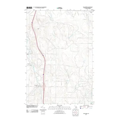
2011 Map of Wolverine
USGS Topo · Published 2011About this map
The Sturgeon River and its multiple branches define the rugged topography of this Cheboygan County landscape. The village of Wolverine serves as a primary hub, situated near the confluence of the West Branch Sturgeon River and the main stem, featuring the Wolverine Post Office. Further north, the smaller settlements of Haakwood and Rondo are connected by the S Straits Hwy, paralleling the watercourse and the Haakwood State Forest Campground.
Find a feature on this map
81 named features on this map. Tap any name to fly to it.
Don’t see what you’re looking for? This feature index may not catch every label — zoom into the map to look around manually.
Map Details
Editions of this 2011 Wolverine Map
This is the sole edition of this map. No revisions or reprints were ever made.
Other maps of this area

1954 · Gaylord
USGS Topo · 1:62,500

1954 · Hetherton
USGS Topo · 1:62,500

1955 · Cheboygan
USGS Topo · 1:250,000

1957 · Tower
USGS Topo · 1:62,500

1957 · Wolverine
USGS Topo · 1:62,500

1958 · Cheboygan
USGS Topo · 1:250,000

1982 · Petoskey
USGS Topo · 1:100,000
1986 · Legrand
USGS Topo · 1:24,000
1986 · Green Timbers
USGS Topo · 1:24,000
1986 · Wildwood
USGS Topo · 1:24,000