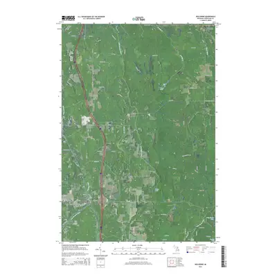
2014 Map of Wolverine
USGS Topo · Published 2014About this map
Wolverine serves as a central hub in this Cheboygan County landscape, situated at the confluence where the W Br Sturgeon River meets the main branch of the Sturgeon River. The area's water-rich geography is further defined by the Little Sturgeon River and Pigeon River, which carve through the terrain alongside smaller bodies like Goose Lake and Echo Lake. The map illustrates a network of rural trails and roads, such as S Rainbow Trl and Beebe School Rd, connecting the village to outlying settlements and historic points.
Find a feature on this map
76 named features on this map. Tap any name to fly to it.
Don’t see what you’re looking for? This feature index may not catch every label — zoom into the map to look around manually.
Map Details
Editions of this 2014 Wolverine Map
This is the sole edition of this map. No revisions or reprints were ever made.
Other maps of this area

1954 · Gaylord
USGS Topo · 1:62,500

1954 · Hetherton
USGS Topo · 1:62,500

1955 · Cheboygan
USGS Topo · 1:250,000

1957 · Tower
USGS Topo · 1:62,500

1957 · Wolverine
USGS Topo · 1:62,500

1958 · Cheboygan
USGS Topo · 1:250,000

1982 · Petoskey
USGS Topo · 1:100,000
1986 · Legrand
USGS Topo · 1:24,000
1986 · Green Timbers
USGS Topo · 1:24,000
1986 · Wildwood
USGS Topo · 1:24,000