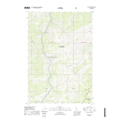
2020 Map of Wood Hump
USGS Topo · Published 2020About this map
The Selway River - Fcrrnr carves through this protected corridor of the Bitterroot National Forest, where high ridgelines and creek flats define the human and natural landscape. Thompson Flat stands as a primary opening in the dense forest, situated near the river and the confluence of Witter Cr. The geography is characterized by prominent elevations such as Goat Ridge and the namesake Wood Hump, with numerous drainage systems like Wilkerson Cr and Storm Cr feeding the larger river system. Toward the southern edge of the survey, the terrain reaches the Salmon National Forest boundary and the high Stripe Creek-Divide. This area is part of the Middle Fork Clearwater Wild and Scenic River system, illustrating the federal management of this remote backcountry region where only the Square Top-West Horse trail provides access through the southern peaks.
Find a feature on this map
40 named features on this map. Tap any name to fly to it.
Don’t see what you’re looking for? This feature index may not catch every label — zoom into the map to look around manually.
Map Details
Editions of this 2020 Wood Hump Map
This is the sole edition of this map. No revisions or reprints were ever made.
Other maps of this area

1956 · Elk City
USGS Topo · 1:250,000

1960 · Elk City
USGS Topo · 1:250,000

1962 · Wood Hump
USGS Topo · 1:24,000

1962 · Beaver Jack Mtn
USGS Topo · 1:24,000

1962 · Blue Joint
USGS Topo · 1:24,000

1962 · Square Top
USGS Topo · 1:24,000

1962 · Horse Creek Butte
USGS Topo · 1:24,000

1962 · Nez Perce Peak
USGS Topo · 1:24,000

1978 · Waugh Mountain
USGS Topo · 1:24,000

1978 · Magruder Mtn
USGS Topo · 1:24,000