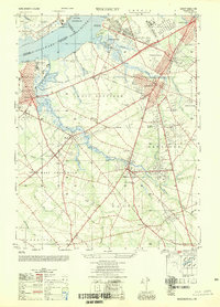
1949 Map of Woodbury
USGS Topo · Published 1954About this map
The Delaware River serves as the industrial and historical anchor for this portion of Gloucester County, where the transition from riverfront industry to inland suburban development is clearly visible. The map highlights the legacy of coastal defense and early American history at Red Bank Battlefield, located near Fort Mercer, and across the water at Fort Mifflin. A significant industrial landmark is the Hog Island Shipyard (Abandoned) on Hog Island, once a vital shipbuilding hub during World War I, now shown in its post-war state.
Find a feature on this map
82 named features on this map. Tap any name to fly to it.
Don’t see what you’re looking for? This feature index may not catch every label — zoom into the map to look around manually.
Map Details
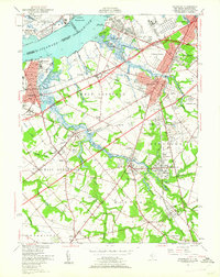
Editions of this 1949 Woodbury Map
2 editions found
Other maps of this area

1890 · Salem
USGS Topo · 1:62,500

1890 · Glassboro
USGS Topo · 1:62,500

1891 · Philadelphia
USGS Topo · 1:62,500

1894 · Chester
USGS Topo · 1:62,500

1894 · Philadelphia
USGS Topo · 1:62,500

1896 · Philadelphia
USGS Topo · 1:62,500

1896 · Chester
USGS Topo · 1:62,500

1898 · Salem
USGS Topo · 1:62,500

1898 · Glassboro
USGS Topo · 1:62,500

1898 · Chester
USGS Topo · 1:62,500
Featured Places
- Philadelphia, PA
- Washington Township, NJ
- Deptford Township, NJ
- West Deptford Township, NJ
- Mantua Township, NJ