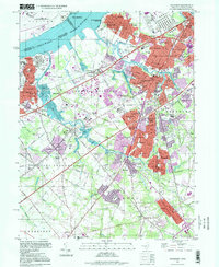
1995 Map of Woodbury
USGS Topo · Published 1999About this map
Red Bank Battlefield County Park anchors the riverfront where the Delaware River separates New Jersey from Philadelphia. This mid-1990s landscape is defined by the dense suburban growth of Woodbury, Westville, and Paulsboro, interlaced with a complex transportation network including the New Jersey Turnpike, Interstate 295, and the Conrail rail lines. The map reveals the industrial character of the shoreline, marked by a massive Tank Farm near Billingsport, while inland areas like Mantua and Sewell maintain distinct residential identities.
Find a feature on this map
93 named features on this map. Tap any name to fly to it.
Don’t see what you’re looking for? This feature index may not catch every label — zoom into the map to look around manually.
Map Details
Editions of this 1995 Woodbury Map
This is the sole edition of this map. No revisions or reprints were ever made.
Other maps of this area

1890 · Salem
USGS Topo · 1:62,500

1890 · Glassboro
USGS Topo · 1:62,500

1891 · Philadelphia
USGS Topo · 1:62,500

1894 · Chester
USGS Topo · 1:62,500

1894 · Philadelphia
USGS Topo · 1:62,500

1896 · Philadelphia
USGS Topo · 1:62,500

1896 · Chester
USGS Topo · 1:62,500

1898 · Salem
USGS Topo · 1:62,500

1898 · Glassboro
USGS Topo · 1:62,500

1898 · Chester
USGS Topo · 1:62,500
Featured Places
- Philadelphia, PA
- Washington Township, NJ
- Deptford Township, NJ
- West Deptford Township, NJ
- Mantua Township, NJ