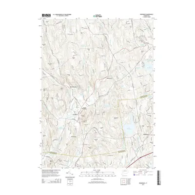
2015 Map of Woodbury
USGS Topo · Published 2015About this map
The Pomperaug River valley serves as the primary corridor for settlement in this part of Litchfield and New Haven counties, where the village of Woodbury and its neighbor North Woodbury are situated. The landscape is defined by a series of prominent rises, including the Orenaug Hills and Orenaug Rocks, which separate the river valley from the drainage of Hesseky Brook and S Brook. To the east, the suburban growth of Watertown and Middlebury is evident near Lake Winnemaug and the Bald Hill Reservoir. This 2015 survey reveals a terrain deeply influenced by water and topography, from the protected acreage of Flanders Wildlife Pond to the numerous family-named peaks like Sperry Hill and Sherman Hill. Genealogists will find several burial sites preserved across the landscape, such as Mount Olive Cem and the Stiles Memorial Cem, documenting the long-standing community centers of the Naugatuck Valley region.
Find a feature on this map
220 named features on this map. Tap any name to fly to it.
Don’t see what you’re looking for? This feature index may not catch every label — zoom into the map to look around manually.
Map Details
Editions of this 2015 Woodbury Map
This is the sole edition of this map. No revisions or reprints were ever made.
Other maps of this area

1889 · Derby
USGS Topo · 1:62,500

1891 · Derby
USGS Topo · 1:62,500

1892 · Danbury
USGS Topo · 1:62,500

1892 · New Milford
USGS Topo · 1:62,500

1893 · Waterbury
USGS Topo · 1:62,500

1893 · New Milford
USGS Topo · 1:62,500

1893 · Derby
USGS Topo · 1:62,500

1904 · New Milford
USGS Topo · 1:62,500

1904 · Waterbury
USGS Topo · 1:62,500

1904 · Litchfield
USGS Topo · 1:125,000