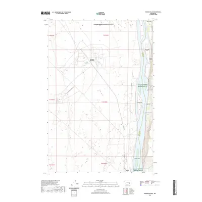
2020 Map of Wooded Island
USGS Topo · Published 2020About this map
The Columbia River dominates this portion of southeastern Washington, where the protected lands of the Hanford Reach National Monument and McNary National Wildlife Refuge converge. The waterway is defined by significant mid-river features including Wooded Island, Homestead Island, and Johnson Island, while the eastern shore rises into rugged breaks marked by Parsons Canyon and Baxter Canyon. To the west, the arid interior shows a more industrial character, influenced by the proximity of the US Department of Energy Res Rd and the presence of Geneva Junction. Small points of settlement like Ruby sit near the river's edge, contrasting with the broad agricultural or open spaces of Ringold Flat and Taylor Flat. This area illustrates the intersection of federal conservation efforts and the strategic management of the river corridor in the Columbia Basin.
Find a feature on this map
25 named features on this map. Tap any name to fly to it.
Don’t see what you’re looking for? This feature index may not catch every label — zoom into the map to look around manually.
Map Details
Editions of this 2020 Wooded Island Map
This is the sole edition of this map. No revisions or reprints were ever made.
Other maps of this area

1917 · Pasco
USGS Topo · 1:125,000

1924 · Hanford
USGS Topo · 1:62,500

1925 · Scooteney Lake
USGS Topo · 1:62,500

1951 · Scooteney Lake
USGS Topo · 1:62,500

1951 · Richland
USGS Topo · 1:62,500

1951 · Hanford
USGS Topo · 1:62,500

1953 · Walla Walla
USGS Topo · 1:250,000

1958 · Walla Walla
USGS Topo · 1:250,000

1965 · Mesa
USGS Topo · 1:62,500

1965 · Eltopia
USGS Topo · 1:62,500