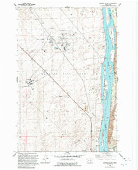
1992 Map of Wooden Island
USGS Topo · Published 1992About this map
The Hanford Site (DOE) dominates this landscape along the Columbia River, revealing the specialized infrastructure of the Cold War era. At the center of the industrial footprint sits the Fast Flux Test Facility, supported by a network of substations, towers, and specialized installations like the Weather Station. This 1990s revision captures a transition point where high-tech energy research facilities and a Radioactive Waste Dump exist in immediate proximity to the Mc Nary National Wildlife Refuge. While the western bank is defined by technical sites like Geneva Junction and the 300 Area, the eastern side of the river remains dominated by natural and agricultural features such as Taylor Flat and Savage Island. The contrast between the rigid, fenced Hanford Site Boundary and the shifting Sand Dunes highlights the unique dual nature of this high-security river corridor.
Find a feature on this map
27 named features on this map. Tap any name to fly to it.
Don’t see what you’re looking for? This feature index may not catch every label — zoom into the map to look around manually.
Map Details
Editions of this 1992 Wooden Island Map
This is the sole edition of this map. No revisions or reprints were ever made.
Other maps of this area

1917 · Pasco
USGS Topo · 1:125,000

1924 · Hanford
USGS Topo · 1:62,500

1925 · Scooteney Lake
USGS Topo · 1:62,500

1951 · Scooteney Lake
USGS Topo · 1:62,500

1951 · Richland
USGS Topo · 1:62,500

1951 · Hanford
USGS Topo · 1:62,500

1953 · Walla Walla
USGS Topo · 1:250,000

1958 · Walla Walla
USGS Topo · 1:250,000

1965 · Mesa
USGS Topo · 1:62,500

1965 · Eltopia
USGS Topo · 1:62,500