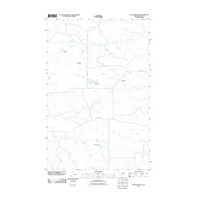
2011 Map of Woodhawk Hill
USGS Topo · Published 2011About this map
Woodhawk Hill and White Horse Butte anchor this high-plains landscape in Fergus County, Montana. The terrain is defined by a dendritic network of seasonal waterways and human-engineered water management, reflecting the necessities of ranching and agriculture in a semi-arid environment. Several small-scale dams, including Kermits Dam, Ford Irrigation Dam, and Othar Number 2 Dam, are distributed across the drainage basins of Woodhawk Creek and Taffy Creek. A modest network of rural thoroughfares such as Woodhawk Rd and Kjorlien Rd connects these points of interest. The presence of Hart Spring and Lambing Camp Creek suggests the area's ongoing importance for livestock management, providing a clear picture of the region's rural infrastructure at the start of the 2010s.
Find a feature on this map
15 named features on this map. Tap any name to fly to it.
Don’t see what you’re looking for? This feature index may not catch every label — zoom into the map to look around manually.
Map Details
Editions of this 2011 Woodhawk Hill Map
This is the sole edition of this map. No revisions or reprints were ever made.
Other maps of this area

1954 · Taffy Ridge
USGS Topo · 1:24,000

1954 · Bird Rapids
USGS Topo · 1:24,000

1954 · Leroy
USGS Topo · 1:24,000

1954 · Sturgeon Island
USGS Topo · 1:24,000

1954 · Lewistown
USGS Topo · 1:250,000

1959 · Lewistown
USGS Topo · 1:250,000

1985 · Woodhawk Hill
USGS Topo · 1:24,000
1985 · Gerhard Corner
USGS Topo · 1:24,000
1985 · Winifred East
USGS Topo · 1:24,000
1985 · Reppe Butte
USGS Topo · 1:24,000