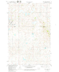
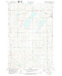
1978 Map of Woodhouse Lake
USGS Topo · Published 1979About this map
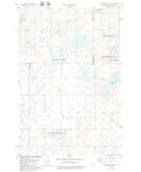
Woodhouse Lake and its surrounding wetlands dominate this prairie landscape at the junction of Kidder, Sheridan, Burleigh, and Wells counties. During the late 1970s, this region of central North Dakota was characterized by vast National Waterfowl Production Areas and the Karl T Frederick State Game Management Area, reflecting a transition toward conservation and resource management. The terrain is marked by distinctive townships such as Mauch, Lynn, Northwest, and Hazel Grove. Evidence of local infrastructure and resource extraction is visible through several Gravel Pits and a Well located in the southern sections. This survey provides a clear view of the section lines and rural drainage patterns before modern agricultural intensification, documenting the intersection of four counties in a sparsely populated but ecologically significant wetland corridor.
Find a feature on this map
14 named features on this map. Tap any name to fly to it.
Don’t see what you’re looking for? This feature index may not catch every label — zoom into the map to look around manually.
Map Details
Editions of this 1978 Woodhouse Lake Map
This is the sole edition of this map. No revisions or reprints were ever made.
Other maps of this area

1952 · New Rockford
USGS Topo · 1:250,000

1954 · McClusky
USGS Topo · 1:250,000

1956 · New Rockford
USGS Topo · 1:250,000

1958 · McClusky
USGS Topo · 1:250,000

1971 · New Rockford
USGS Topo · 1:250,000
1972 · Tuttle
USGS Topo · 1:24,000
1978 · Goodrich SW
USGS Topo · 1:24,000
1978 · Goodrich East
USGS Topo · 1:24,000
1978 · Senior Lake
USGS Topo · 1:24,000
1978 · Goodrich West
USGS Topo · 1:24,000