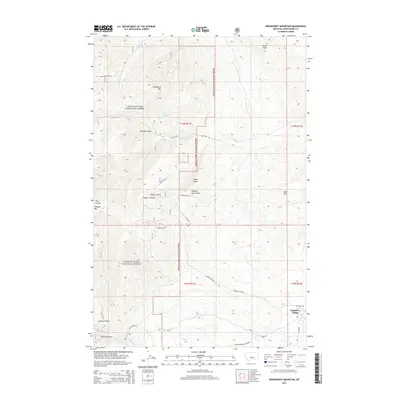
2014 Map of Woodhurst Mountain
USGS Topo · Published 2014About this map
Sapphire Village sits in the southeastern corner of this Judith Basin terrain, where the foothills of the Lewis & Clark National Forest meet the drainage of Yogo Cr. The landscape is defined by its deep coulees and named peaks, including Woodhurst Mtn and the prominent Tepee Butte. The naming of Sawmill Gulch and Dipping Vat Coulee suggests the historic intersection of timber extraction and cattle ranching that long shaped this region. Access into these mountain draws is provided by several primitive routes, notably Yogo Rd and Sage Cr Rd. Water sources are sparse but critical for local activity, represented by Mitchell Spring and various seasonal flows through Moose Coulee and Missouri Coulee. The presence of labels like Green Mtn No 3 indicates localized surveying or resource markers within the forest boundary.
Find a feature on this map
31 named features on this map. Tap any name to fly to it.
Don’t see what you’re looking for? This feature index may not catch every label — zoom into the map to look around manually.
Map Details
Editions of this 2014 Woodhurst Mountain Map
This is the sole edition of this map. No revisions or reprints were ever made.
Other maps of this area

1886 · Little Belt Mts.
USGS Topo · 1:250,000

1890 · Fort Benton
USGS Topo · 1:250,000

1892 · Fort Benton
USGS Topo · 1:250,000

1894 · Little Belt Mts.
USGS Topo · 1:250,000

1897 · Fort Benton
USGS Topo · 1:250,000

1897 · Little Belt Mts.
USGS Topo · 1:250,000

1898 · Little Belt Mts.
USGS Topo · 1:250,000

1902 · Little Belt Mts.
USGS Topo · 1:250,000

1948 · White Sulphur Springs
USGS Topo · 1:250,000

1954 · Great Falls
USGS Topo · 1:250,000