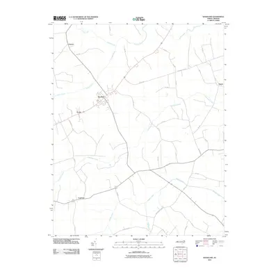
2010 Map of Woodland
USGS Topo · Published 2010About this map
Woodland serves as a central hub in this rural landscape, situated at a crossroads where agricultural lands meet several vital waterways. The drainage patterns of Northampton County are clearly defined, with Potecasi Creek flowing through the north and Ahoskie Creek to the south. The terrain is characterized by expansive wetlands and low-lying areas, notably Urahaw Swamp, which influences the local road network and settlement placement. Smaller hamlets like Potecasi, George, and Eagletown are connected by a web of state-maintained routes such as NC-1533 and NC-1158. Local landmarks like Benthall Bridge Rd and Mill Branch Church Rd provide specific reference points for family researchers and those tracing local history. The map illustrates how human settlement has adapted to the presence of significant tributaries like Cutawhiskie Creek, with roads often paralleling the water's edge or seeking high ground between the marshes.
Find a feature on this map
39 named features on this map. Tap any name to fly to it.
Don’t see what you’re looking for? This feature index may not catch every label — zoom into the map to look around manually.
Map Details
Editions of this 2010 Woodland Map
This is the sole edition of this map. No revisions or reprints were ever made.
Other maps of this area

1953 · Norfolk
USGS Topo · 1:250,000

1962 · Norfleet
USGS Topo · 1:24,000

1972 · Aulander
USGS Topo · 1:24,000
1973 · Murfreesboro
USGS Topo · 1:24,000
1973 · Conway
USGS Topo · 1:24,000

1973 · Kelford
USGS Topo · 1:24,000

1974 · Rich Square
USGS Topo · 1:24,000
1975 · Galatia
USGS Topo · 1:24,000

1977 · Union
USGS Topo · 1:24,000

1977 · Woodland
USGS Topo · 1:24,000