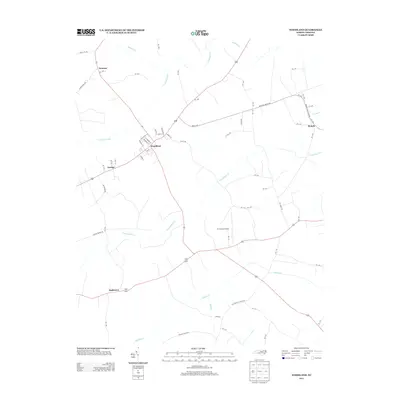
2013 Map of Woodland
USGS Topo · Published 2013About this map
Woodland stands as the primary residential center in this part of Northampton County, characterized by a detailed street grid including Myrtle St, Sycamore St, and Peachtree St. The surrounding landscape is defined by an intricate network of coastal plain waterways and wetlands, most notably the expansive Urahaw Swamp and the meandering channels of Potecasi Cr and Cutawhiskie Cr.
Find a feature on this map
68 named features on this map. Tap any name to fly to it.
Don’t see what you’re looking for? This feature index may not catch every label — zoom into the map to look around manually.
Map Details
Editions of this 2013 Woodland Map
This is the sole edition of this map. No revisions or reprints were ever made.
Other maps of this area

1953 · Norfolk
USGS Topo · 1:250,000

1962 · Norfleet
USGS Topo · 1:24,000

1972 · Aulander
USGS Topo · 1:24,000
1973 · Murfreesboro
USGS Topo · 1:24,000
1973 · Conway
USGS Topo · 1:24,000

1973 · Kelford
USGS Topo · 1:24,000

1974 · Rich Square
USGS Topo · 1:24,000
1975 · Galatia
USGS Topo · 1:24,000

1977 · Union
USGS Topo · 1:24,000

1977 · Woodland
USGS Topo · 1:24,000