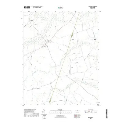
2019 Map of Woodland
USGS Topo · Published 2019About this map
Woodland serves as the central hub of this eastern North Carolina landscape, where the local street grid including W Main St and Spruce St meets the rural agricultural hinterland of Northampton and Hertford counties. The terrain is defined by a dendritic network of low-lying wetlands and drainage systems, most notably Urahaw Swamp and Potecasi Creek, which dictate the placement of small communities like George and Potecasi. The modern infrastructure of the Tri-County Airport stands in contrast to the older crossroads settlements of Menola and Eagletown. These hamlets are connected by a web of named rural routes such as Mary Odom Rd and Pleasant Grove Rd, reflecting a landscape deeply tied to family-held land and small-scale transit between the various creeks and swamps that crisscross the coastal plain.
Find a feature on this map
57 named features on this map. Tap any name to fly to it.
Don’t see what you’re looking for? This feature index may not catch every label — zoom into the map to look around manually.
Map Details
Editions of this 2019 Woodland Map
This is the sole edition of this map. No revisions or reprints were ever made.
Other maps of this area

1953 · Norfolk
USGS Topo · 1:250,000

1962 · Norfleet
USGS Topo · 1:24,000

1972 · Aulander
USGS Topo · 1:24,000
1973 · Murfreesboro
USGS Topo · 1:24,000
1973 · Conway
USGS Topo · 1:24,000

1973 · Kelford
USGS Topo · 1:24,000

1974 · Rich Square
USGS Topo · 1:24,000
1975 · Galatia
USGS Topo · 1:24,000

1977 · Union
USGS Topo · 1:24,000

1977 · Woodland
USGS Topo · 1:24,000