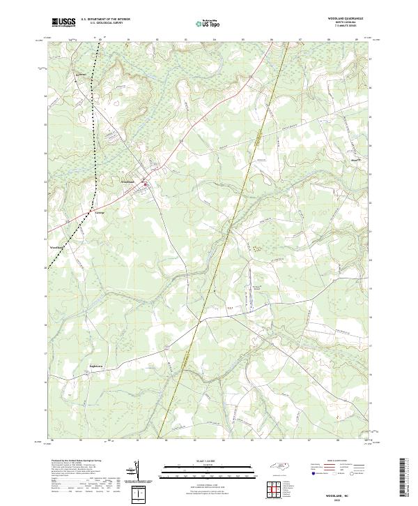
2022 Map of Woodland
USGS Topo · Published 2022About this map
Settlements like Woodland and Potecasi anchor this North Carolina coastal plain landscape, where the flat terrain is defined by an intricate network of wetlands and creek systems. The extensive Urahaw Swamp dominates the western portion of the map, while the Northampton Co Hertford Co line runs through the center, marking a significant administrative boundary. Small crossroads communities including George, Eagletown, and Menola are linked by a grid of rural roads named for local families and landmarks, such as Benthall Bridge Rd and Hebron Church Rd. The presence of the Tri-County Airport near Ahoskie Cr indicates the area's modern infrastructure amidst its traditional agricultural character. The drainage patterns of Potecasi Creek and Cutawhiskie Cr dictate the layout of timber tracts and fields, preserving the historical spatial relationship between the land's hydrology and its human habitation.
Find a feature on this map
59 named features on this map. Tap any name to fly to it.
Don’t see what you’re looking for? This feature index may not catch every label — zoom into the map to look around manually.
Map Details
Editions of this 2022 Woodland Map
This is the sole edition of this map. No revisions or reprints were ever made.
Other maps of this area

1953 · Norfolk
USGS Topo · 1:250,000

1962 · Norfleet
USGS Topo · 1:24,000

1972 · Aulander
USGS Topo · 1:24,000
1973 · Murfreesboro
USGS Topo · 1:24,000
1973 · Conway
USGS Topo · 1:24,000

1973 · Kelford
USGS Topo · 1:24,000

1974 · Rich Square
USGS Topo · 1:24,000
1975 · Galatia
USGS Topo · 1:24,000

1977 · Union
USGS Topo · 1:24,000

1977 · Woodland
USGS Topo · 1:24,000