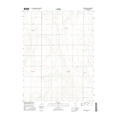
2016 Map of Woodlin School
USGS Topo · Published 2016About this map
Woodlin School stands as a central institutional landmark in this expansive section of Washington County, where the high plains are defined by a grid of county roads and meandering drainage systems. The landscape is primarily shaped by the headwaters and branches of Plum Bush Cr, including its East Fork Plum Bush Cr, which wind through the township boundaries of T2S and T3S. These ephemeral waterways, along with Vega Cr and Beaver Cr, dictate the subtle topography of the region. The map reveals a strictly organized rural infrastructure, where routes such as Co RD 16 and Co RD 19 provide the primary framework for local transit between isolated homesteads and agricultural plots.
Find a feature on this map
20 named features on this map. Tap any name to fly to it.
Don’t see what you’re looking for? This feature index may not catch every label — zoom into the map to look around manually.
Map Details
Editions of this 2016 Woodlin School Map
This is the sole edition of this map. No revisions or reprints were ever made.
Other maps of this area

1954 · Limon
USGS Topo · 1:250,000

1957 · Limon
USGS Topo · 1:250,000

1958 · Limon
USGS Topo · 1:250,000

1973 · Woodrow
USGS Topo · 1:24,000

1973 · Antelope Creek West
USGS Topo · 1:24,000

1973 · Dry Gulch
USGS Topo · 1:24,000

1973 · Last Chance NW
USGS Topo · 1:24,000
1973 · Woodrow NW
USGS Topo · 1:24,000

1973 · Lindon
USGS Topo · 1:24,000

1973 · Last Chance
USGS Topo · 1:24,000