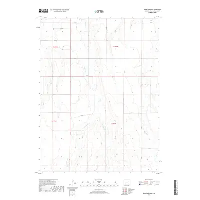
2019 Map of Woodlin School
USGS Topo · Published 2019About this map
Plum Bush Cr and its tributaries define the drainage patterns of this high plains landscape in eastern Colorado. The map shows the convergence of the W Fork Plum Bush Cr and E Fork Plum Bush Cr, creating a network of seasonal watercourses that cut through the undulating terrain. A rigid grid of county roads, including Co RD 21, Co RD 16, and Co RD G, follows the Public Land Survey System township and range lines, illustrating how the region was systematically partitioned for ranching and agriculture. The eastern portion of the sheet is marked by the winding path of Vega Cr, while Beaver Cr touches the northwestern corner. This 2019 survey documents the enduring rural character of Washington County, where the landscape remains dominated by expansive open tracts and isolated water features.
Find a feature on this map
25 named features on this map. Tap any name to fly to it.
Don’t see what you’re looking for? This feature index may not catch every label — zoom into the map to look around manually.
Map Details
Editions of this 2019 Woodlin School Map
This is the sole edition of this map. No revisions or reprints were ever made.
Other maps of this area

1954 · Limon
USGS Topo · 1:250,000

1957 · Limon
USGS Topo · 1:250,000

1958 · Limon
USGS Topo · 1:250,000

1973 · Woodrow
USGS Topo · 1:24,000

1973 · Antelope Creek West
USGS Topo · 1:24,000

1973 · Dry Gulch
USGS Topo · 1:24,000

1973 · Last Chance NW
USGS Topo · 1:24,000
1973 · Woodrow NW
USGS Topo · 1:24,000

1973 · Lindon
USGS Topo · 1:24,000

1973 · Last Chance
USGS Topo · 1:24,000