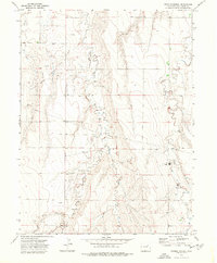
1973 Map of Woodlin School
USGS Topo · Published 1977About this map
Ramp Oil Field defines the industrial character of this eastern Colorado landscape during the early 1970s. Located in Washington County, the terrain is marked by a network of energy infrastructure, including numerous Oil Wells, a dedicated Pipeline, and a Landing Strip that suggests the scale of operations in this rural area. Settlement is sparse, anchored by the central Woodlin School, which serves as a solitary landmark among the rolling drainage basins of Plum Bush Creek and Vega Creek. The map detail captures the convergence of the East Fork and West Fork, illustrating how natural watercourses and man-made resource extraction shaped the local economy and movement across the high plains.
Find a feature on this map
14 named features on this map. Tap any name to fly to it.
Don’t see what you’re looking for? This feature index may not catch every label — zoom into the map to look around manually.
Map Details
Editions of this 1973 Woodlin School Map
This is the sole edition of this map. No revisions or reprints were ever made.
Other maps of this area

1954 · Limon
USGS Topo · 1:250,000

1957 · Limon
USGS Topo · 1:250,000

1958 · Limon
USGS Topo · 1:250,000

1973 · Woodrow
USGS Topo · 1:24,000

1973 · Antelope Creek West
USGS Topo · 1:24,000

1973 · Dry Gulch
USGS Topo · 1:24,000

1973 · Last Chance NW
USGS Topo · 1:24,000
1973 · Woodrow NW
USGS Topo · 1:24,000

1973 · Lindon
USGS Topo · 1:24,000

1973 · Last Chance
USGS Topo · 1:24,000