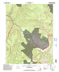
1995 Map of Woodrow
USGS Topo · Published 1998About this map
Woodrow and the surrounding high-elevation terrain of Monongahela National Forest are captured in this mid-1990s survey, illustrating a landscape defined by industrial extraction and public conservation. In the north, Strip Mines indicate the ongoing economic influence of coal, while the Cranberry Wilderness and the Handley Public Hunting and Fishing Area represent significant protected zones. The topography is anchored by prominent peaks including Big Spruce Knob, Red Spruce Knob, and Turkey Mountain. The drainage network, featuring the Williams River and Tea Creek, flows through steep valleys between Gauley Mountain and Sugar Creek Mountain. Cultural landmarks like the West Alois Ch and the Highland Scenic Parkway provide key reference points for local history and development in the Edray District and Little Levels region.
Find a feature on this map
40 named features on this map. Tap any name to fly to it.
Don’t see what you’re looking for? This feature index may not catch every label — zoom into the map to look around manually.
Map Details
Editions of this 1995 Woodrow Map
This is the sole edition of this map. No revisions or reprints were ever made.
Other maps of this area

1891 · Huntersville
USGS Topo · 1:125,000

1894 · Huntersville
USGS Topo · 1:125,000

1915 · Webster Springs
USGS Topo · 1:48,000

1918 · Webster Springs
USGS Topo · 1:62,500

1923 · Lobelia
USGS Topo · 1:48,000

1923 · Marlinton
USGS Topo · 1:48,000

1923 · Mingo
USGS Topo · 1:48,000

1925 · Mingo
USGS Topo · 1:62,500

1925 · Marlinton
USGS Topo · 1:62,500

1925 · Lobelia
USGS Topo · 1:62,500