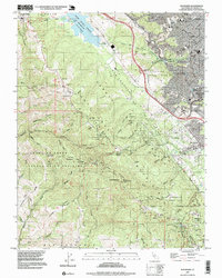
1997 Map of Woodside
USGS Topo · Published 1999About this map
The San Andreas Rift Zone bisects this portion of the Santa Cruz Mountains, creating a landscape defined by deep gulches and wooded ridges at the close of the twentieth century. Dense residential development in San Carlos and Redwood City transitions sharply into the protected open spaces of Edgewood County Park and Wunderlich County Park. In the western portion, the rugged terrain is marked by the winding route of Skyline Blvd and the historic settlement of Grabtown, which stands near the headwaters of Tunitas Creek.
Find a feature on this map
75 named features on this map. Tap any name to fly to it.
Don’t see what you’re looking for? This feature index may not catch every label — zoom into the map to look around manually.
Map Details
Editions of this 1997 Woodside Map
This is the sole edition of this map. No revisions or reprints were ever made.
Other maps of this area

1892 · San Mateo
USGS Topo · 1:62,500

1896 · San Mateo
USGS Topo · 1:62,500

1897 · Palo Alto
USGS Topo · 1:62,500

1899 · Palo Alto
USGS Topo · 1:62,500

1899 · Haywards
USGS Topo · 1:62,500

1899 · San Mateo
USGS Topo · 1:62,500

1902 · Santa Cruz
USGS Topo · 1:125,000

1915 · San Mateo
USGS Topo · 1:62,500

1915 · Haywards
USGS Topo · 1:62,500

1939 · San Mateo
USGS Topo · 1:62,500